Your donation helps keep Hoosier History Live on the air, on the web and in your inbox!
|
Oct. 29, 2016 show
Capital move from Corydon to Indy and early roads
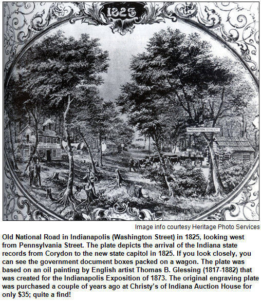
 Have you ever wondered how, during an October in the 1820s, all of the money in the state treasury was moved through the Indiana wilderness from Corydon, our first state capital? Have you ever wondered how, during an October in the 1820s, all of the money in the state treasury was moved through the Indiana wilderness from Corydon, our first state capital?
There were no Brink's armored vehicles, no Indiana State Police. And very few roads existed through the dense forest of towering trees that prevailed over much of early Indiana when the new capital city of Indianapolis was created. The site was chosen primarily for its central location as pioneers began to move north.
We will explore the transport of the state's property and money in October 1824. The treasury was kept in silver during the move by a caravan of horse-drawn covered wagons. The caravan included state officials and their extended families, some of whom slept by the silver (which was in crates) to protect it during the rigorous journey.
Also during our show, we will explore the creation of early roads through the wilderness to the new capital city, including a road that was crucial for the state capital's move.
 The trip from Corydon to Indy - which takes about two hours today - lasted nearly two weeks then, even with a team of horses hailed as "none finer in Indiana." The trip from Corydon to Indy - which takes about two hours today - lasted nearly two weeks then, even with a team of horses hailed as "none finer in Indiana."
The first two roads created in the wilderness to Indianapolis were known as Mauxferry (occasionally spelled Mauckferry) Road and the Madison State Road, sometimes called "Indiana's mother roads." There's a direct connection between them and today's Madison Avenue on the south side of Indianapolis.
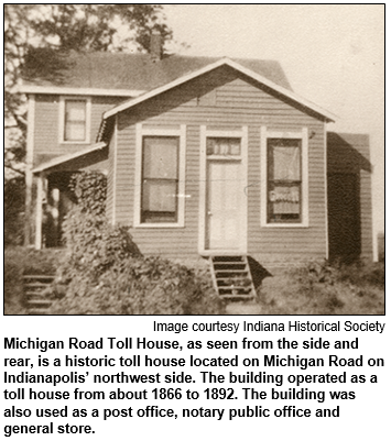
We also will delve into the creation of Michigan Road. It was built in the 1830s to connect Ohio River towns with Indianapolis - and, eventually, to Lake Michigan.
Our guide for this time-traveling journey will be Jay Allen, an Indianapolis-based historic researcher and author who owns and lives in the historic Bates-Hendricks House, which is listed on the National Register of Historic Places. The original part of the home (one of the oldest in Indy) was built in the early 1820s.
Many of the details about the move of the precious treasury have endured thanks to the sister-in-law of Samuel Merrill, the state's treasurer. His sister-in-law, Mary Catherine Anderson (later Mary Catherine Naylor), wrote a memoir that included a description of the journey, on which she was a participant. In addition to the treasury, the property that was moved included the state's printing press.
 The creation of roads in the Indiana wilderness was hardly a breeze. Tall trees had to be felled, stumps removed (if possible) and muck endured. The creation of roads in the Indiana wilderness was hardly a breeze. Tall trees had to be felled, stumps removed (if possible) and muck endured.
On previous Hoosier History Live shows, we have explored the creation of the Old National Road (now U.S. 40 in Indiana) and the Lincoln Highway in northern Indiana.
The Mauxferry Road started at the Ohio River at the town of Mauckport, then went to Corydon. Completed in 1824 to Indianapolis, the Mauxferry Road was used to move the state's treasury and property from the old capital to the new.
Madison State Road was completed the next year, connecting Madison with Indianapolis. (At that point, Madison, as a bustling river town, was much larger than the new state capital in the wilderness.)
The Mauxferry and Madison State roads met - or joined with each other - before reaching Marion County, where the "mother road" became Madison Avenue. According to research by our guest Jay Allen, construction workers doing excavations on the south side of Indy during the 1920s were startled when they discovered a pioneer wooden road under Madison Avenue.
Michigan Road, built during the 1830s and often described as "one of Indiana's earliest highways", began as a dirt path through dense forest. It eventually connected Madison and Indy with South Bend and what became Michigan City on Lake Michigan.
According to the Historic Michigan Road Association, almost all of the original route survives of Michigan Road, which opened "the state to commerce and settlement." Michigan Road goes through 14 counties and cities, including Greensburg, Logansport, Rochester and Plymouth.
Our guest Jay Allen, an Indy native, is the former president of the Indiana Photographic Society and the Bates Hendricks Neighborhood Association. He runs a grandfather clock repair company.
Learn more:
Roadtrip: Finding Home at IRT
Our guest Roadtripper is none other than acclaimed Indiana Repertory Theatre equity actor David Alan Anderson, who will invite listeners to the Indiana Repertory's bicentennial production Finding Home: Indiana at 200, which runs through Nov. 20. Mr. Anderson has several roles, including pieces that cover Indiana Avenue, slavery and the underground railroad, basketball and the NAACP, and Ryan White.
Finding Home: Indiana at 200 is a collaboration of more than 30 Hoosier writers. The material is split into two evenings: blue and gold; and nearly 70 percent of the content is unique.
Come hear from Madame C.J. Walker, James Whitcomb Riley and other notable Hoosiers as they tell their stories, set to live music by the Grimm Family Band.
And our own Nelson Price will be facilitating a Q&A with the audience after the Sunday, Oct. 30 matinee performance at 2 p.m. and then again after the Nov. 8 performance at 6 p.m.!
History Mystery
A town located on the Old National Road (U.S. 40) in eastern Indiana was founded in the 1830s. Known for its antique shops and a historic district listed on the National Register of Historic Places, the town is named after a city in England.
The eastern Indiana town has a population of about 1,900 people. It has the word "city" in its name.
Question: What is the town on the Old National Road/U.S. 40?
The call-in number is (317) 788-3314. Please do not call into the show until you hear Nelson pose the question on the air, and please do not try to win the prize if you have won any other prize on WICR during the last two months. You must be willing to give your name and address to our engineer and be willing to be placed on the air.
The prize is a Family 4-Pack to Conner Prairie, including 4 tickets to the 1859 Balloon Voyage, courtesy of Conner Prairie.
Your Hoosier History Live team,
Nelson Price, host and creative director
Molly Head, producer, (317)
927-9101
Richard Sullivan, webmaster and tech director
Pam Fraizer, graphic designer
Garry Chilluffo, media+development director
www.hoosierhistorylive.org


Please tell our sponsors that you appreciate their support: Indiana Authors Award | Indiana Historical Society | Indiana Repertory Theatre | Lucas Oil | Shirley Brothers Mortuaries & Crematory | Story Inn| Yats Cajun Creole Restaurant
  Acknowledgments to Monomedia, Visit Indy, WICR-FM, Fraizer Designs, Heritage Photo & Research Services, Derrick Lowhorn and many other individuals and organizations. We are an independently produced program and are self-supporting through organizational sponsorships and individual contributions. We do not receive any government funding. Visit our website to learn how you can support us financially. Also, see our Twitter feed and our Facebook page for regular updates. Acknowledgments to Monomedia, Visit Indy, WICR-FM, Fraizer Designs, Heritage Photo & Research Services, Derrick Lowhorn and many other individuals and organizations. We are an independently produced program and are self-supporting through organizational sponsorships and individual contributions. We do not receive any government funding. Visit our website to learn how you can support us financially. Also, see our Twitter feed and our Facebook page for regular updates.
Thanks!
Keeping us going
Thanks to new or renewal contributors Stacia Gorge, Sally Cook and Jo Ellen Meyers Sharp!
Nov. 5, 2016 show - encore presentation
Maps of Indiana
On a map created in 1778, the name "Indiana" appears for a region that later became part of West Virginia. Other maps from the late 1700s and early 1800s reflect border disputes between Michigan, Ohio, Illinois and the Hoosier state.
During the early auto era, the first so-called "highway map" of Indiana may have been one distributed in 1919. 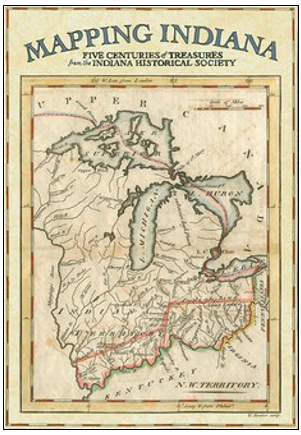 A map of Indiana's gravel roads was produced in 1895, while a bicycle route map helped 1901 travelers. A map of Indiana's gravel roads was produced in 1895, while a bicycle route map helped 1901 travelers.
All of them are among the historic maps explored during this encore broadcast of a show from our Hoosier History Live archives (its original air date was Feb. 13, 2016). Nelson is joined in studio by two Indiana Historical Society staff members. Eric Mundell and Amy Vedra are co-authors of Mapping Indiana (IHS Press), a book that features 107 of the more than 1,700 maps in the society's collections. The maps include Old World depictions of North America, including the area that became Indiana.
"Early mapmakers often were working with unknown areas," notes Eric, a sixth-generation Hoosier who is the director of collections management at the IHS. Amy, his colleague, is a native of Griffith in northwest Indiana and the IHS director of reference services.
Among the oldest maps in the IHS collection, which spans five centuries, is one created in 1540 by Sebastian Munster, a well-known German mapmaker. Although its depiction of North America is "malformed", as Amy puts it, our guests report that the map has held up well because it, like others during the era, was created on "rag paper," a type of cloth.
In Indianapolis, early mapmakers included civic leader William Sullivan (1803-86), an engineer and surveyor who created hand-drawn "bird's-eye view" depictions of the Hoosier capital during the 1830s. Mapping Indiana also includes "bird's-eye view" depictions of such Hoosier cities as Lafayette, South Bend, Greencastle and Madison.
How to Drive to Brown County is the title of a map produced in 1918 for early motorists. The map includes "road conditions" information as it guides travelers to the isolated, hilly county then becoming known for its colony of artists that included Hoosier Group painter T.C. Steele.
Sanborn maps of cities were created for fire insurance purposes. Because they often include construction details of buildings such as their height, Sanborn maps have been extremely helpful to historic researchers.
According to our guest Eric Mundell, investors in the undeveloped region labeled "Indiana" (that later became a portion of West Virginia) on the 1778 map included Benjamin Franklin. A settlement planned for the area in the 1770s never happened.
But the word "Indiana" continued to pop up on maps of wilderness areas that eventually became parts of other states - indicating the name was being kept in mind as pioneers moved west.
Learn more:
© 2016 Hoosier History Live. All rights reserved.
|